


Municipalities and companies can use the data to understand the effectiveness of the event implementation and utilize it for policy planning, improvement of the next policy, and investment decisions.
*As of October 27, 2025, according to Geolonia.

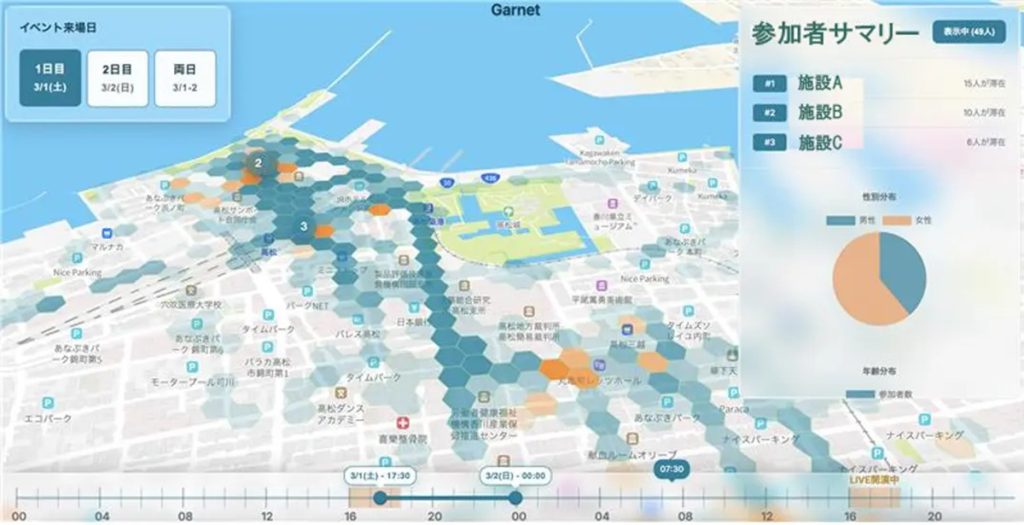
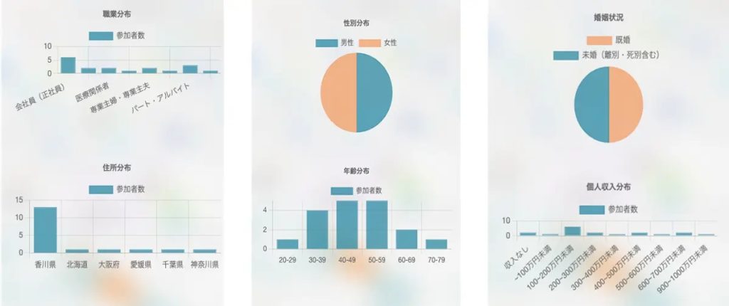
The images are for illustrative purposes only. Actual specifications may differ.
background
Outdoor events utilizing local resources are actively held throughout Japan as an effective means of regional development and tourism promotion. In recent years, in particular, public-private partnerships have accelerated with the aim of expanding the number of people interacting with each other and creating economic benefits. However, because outdoor events allow spectators to move and disperse freely, it is difficult to quantitatively measure the implementation effects, such as the number of visitors, their propensity to stay, and the ripple effects on the local community.
Local outdoor events are one of the essential measures in achieving sustainable regional development. In order to maximize their value and utilize them for policy planning and improvement, efforts to visualize event effects and impacts based on data are required.
Geolonia, in collaboration with Geo Technologies, will provide the industry's first service that quantitatively and centrally visualizes the effectiveness of local events through a unique method that crosses human flow data with location-based surveys.
Service Overview
This service uses Geo-Technologies' anonymized human flow data "Geo-People" to enable detailed analysis of audience behavior trends and length of stay before and after an event. The service enables the visualization of the ripple effects of the event on the surrounding area by providing a chronological history of the participants' behavior, such as when and where they came from and where they moved to.
Geo-Research," a location-based survey service, can also be used to collect high-quality "real voices," such as satisfaction with the experience and intention to revisit.
Geolonia's visualization technology integrates and dashboards these data to create a system that enables local governments and companies engaged in promotional activities to intuitively and quantitatively grasp the effects and impact of their events.
Expected Benefits and Future Prospects
Through this initiative, it will be possible to clearly demonstrate the effects of outdoor events on attracting visitors and the ripple effects on the local economy in the form of objective data. From human flow data, the number of visitors and the time they spend at the event, and from survey data, the level of customer satisfaction and audience comments such as "I want to come back again" can be obtained, enabling a multifaceted evaluation of the contribution the event makes to the community.
This allows local governments and companies to accurately grasp the effects of the event, improve next time measures, develop strategies, and maximize the value of the event.
By providing this solution, Geolonia and Geo Technologies will promote data-driven event management and contribute to the development of the entertainment industry and regional promotion.
About Geotechnologies Corporation
Geotechnologies has consistently provided digital maps since its establishment in 1994. The following year, the company launched MapFan map software. Since then, we have been a pioneer in providing i-mode maps for the first time in Japan, map data and location information solutions for car navigation systems and corporate clients, as well as maps for AD/ADAS, which are essential for realizing advanced automated driving.
In addition, contact with users of applications, as exemplified by the poiLife application "Trima" released in 2020, is enabling real-time understanding of "insights" into real-world situations, such as people's movements and the awareness behind them.
Geo Technologies aims to contribute to society by providing "insights of the present moment" and realizing a more comfortable and sustainable world by using cutting-edge technology to analyze the vast amount of big data, including human flows, and geospatial data that we have been maintaining for about 30 years. We are also committed to providing the most up-to-date and accurate information on the world.
| name of company | Geotechnologies Corporation |
| Establishment | May 1, 1994 |
| Location | Bunkyo Green Court Center Office, 2-28-8 Honkomagome, Bunkyo-ku, Tokyo |
| representative | President and Representative Director Yoichiro Yatsugi |
| Business Overview | Automotive Business / Enterprise Business / Marketing Business / Consumer Business |
| uniform resouce locator | https://geot.jp/ |
About Geolonia Inc.
Location-based startup established in August 2019. A GSI partner and member of the UN Open GIS Initiative, the company provides web map provision business, location information development support business, and location platform. Representative Miyauchi proposes architectures for building smart cities as a member of the study committee for spatial ID, base registry, and real estate ID, among others.
| name of company | Geolonia Corporation |
| Establishment | August 2019 |
| Location | Bunkyo Green Court Center Office, 2-28-8 Honkomagome, Bunkyo-ku, Tokyo |
| representative | Takayuki Miyauchi, Representative Director, CEO and President |
| Business Overview | Cloud business related to location information, system development related to location information, and various data sales |
| uniform resouce locator | https://www.geolonia.com/ |




 JA
 EN
