


Background of VAKAN Introduction
In a coronavirus disaster, social distance (social distance), which ensures distance between people, and avoidance of close proximity are required to prevent the spread of infection. Measures to prevent the spread of novel coronaviruses are no exception, even in evacuation centers opened during disasters, where it is important to ensure distance and zoning of people who are unwell. On the other hand, under such circumstances, the number of people that can be accommodated in each shelter may be smaller than in the past, and it will be necessary to avoid concentrating people in some shelters and to disperse the evacuation process.
VACAN is a real-time information distribution platform for evacuation centers, which enables the distribution of real-time information on the vacancies of evacuation centers. VACAN Maps" (https://vacan.comThe VACAN Maps feature, called "VACAN Maps", allows evacuees to access these VACAN Maps via PC or smartphone to check the location of each shelter and its crowding status. The information on how crowded the shelters are is updated by the staff of each shelter through the management screen on the Internet. The display has four levels: "Available," "Slightly crowded," "Crowded," and "Full.
Currently, VACAN Maps is being used by municipalities nationwide for evacuation centers, and since its introduction by Tama City in Tokyo in August 2020, 13,000 locations and over 200 municipalities* have introduced the service in a year and a half. Population coverage of the service has surpassed 191 TP3T.
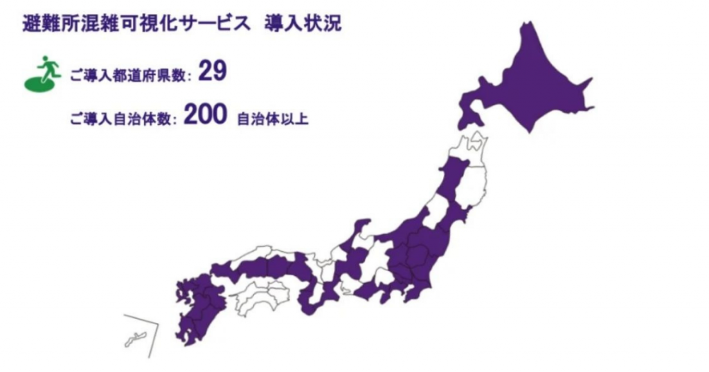
*Sometimes introduced on a county-by-county basis.
About "VACAN Maps," a map-based real-time vacancy information distribution service
VACAN Maps, one of the functions of the real-time vacancy information distribution platform "VACAN," displays the availability and congestion of nearby facilities on a map.
Vacancy information is detected and distributed in various ways according to the environment and budget of the store or facility, such as automatic detection and determination by AI based on data on the condition of the facility obtained by sensors and cameras, and detection using tablet devices in stores. For use at evacuation centers, to ensure stable detection and distribution of congestion information even in the event of a disaster, staff at each evacuation center update the congestion status from an Internet-based management screen, without using any sensors. The availability information is displayed in four levels: "Available," "Slightly crowded," "Crowded," and "Full.
Since the launch of this function in June 2020*, it has been used in a wide variety of facilities and locations nationwide, including restaurants, commercial facilities, and polling places, as well as tourist attractions such as Enoshima, Ise Shrine, and Dazaifu Tenmangu Shrine.
*Provision to evacuation centers began in August of the same year.

Utilization Results
Since its launch, the service has been used by municipalities nationwide, including the following examples. In addition, new ways of utilizing the service have been developed, such as conducting online evacuation drills, with the aim of avoiding a close call in the event of a Corona disaster.
[Examples of utilization (excerpts)
Nichinan City, Miyazaki Prefecture:
The system was utilized when evacuation orders were issued after Typhoon No. 10 hit Kyushu in September 2020. Although the city has a population of about 50,000, it was accessed by more than 10,000 people, with some residents commenting that it was easy to understand.
Fukushima Prefecture, etc:
Koriyama City, Fukushima City, and other cities in Fukushima Prefecture utilized the system after the Fukushima Prefecture earthquake in February 2021. Although the evacuation centers were opened at short notice due to the earthquake, there was no overcrowding at the evacuation centers.
Nagasaki City, Nagasaki Prefecture:
In May 2021, the company will conduct an evacuation drill using VACAN to conduct online drills to ensure safety even in the Corona Disaster, which avoids the risk of density.
Kyushu region, etc:
Utilized by local governments in Kyushu, Hiroshima, Okayama, and other prefectures after heavy rains hit Kyushu and other prefectures in August 2021. 1 million accesses/day were recorded.
Oita Prefecture:
Oita City and other cities will take advantage of the earthquake that occurred in January 2022 with the epicenter in the Hyuga Sea.
About Bakan Corporation
Bakan is a J-Startup 2019 selected company by the Ministry of Economy, Trade and Industry, a public-private support program. It utilizes IoT and AI to collect and provide information on all kinds of vacancies. The company provides a service that automatically detects the availability of restaurant areas, cafes, restrooms, tourist attractions, polling places, evacuation centers, etc. using sensors and cameras, and distributes the information to digital signage, smartphones, etc. VAKANHa, The system has been introduced in more than 200 municipalities nationwide.
| name of company | Bakan Corporation |
| Establishment | June 2016 |
| Location | Sumitomo Fudosan Nagatacho Building 2F, 2-17-3 Nagatacho, Chiyoda-ku, Tokyo |
| representative | Goshin Kono |
| uniform resouce locator | https://corp.vacan.com |




 JA
 EN
