


Objectives and Background of the Project
The spread of the new coronavirus infection has led to a sharp decline in the number of domestic and international travelers, making it difficult for local tourist destinations to attract visitors. Safety and security" are also important criteria for selecting restaurants, and there is a demand for information on infection control measures at stores and a shift to "non-face-to-face, non-contact" services that allow customers to order without having contact with store staff. In addition, there is a need to improve the quality of life in cities and revitalize local economies in order to develop cities in response to the "new normal" brought about by the new coronas.
Against this backdrop, the three companies have developed a smartphone service that integrates a 3D city model with a VPS, an AR restaurant guide using highly accurate augmented reality, and a mobile ordering system. The aim is to provide a "non-face-to-face, non-contact" service that allows users to use their own smartphones to search for safe and secure restaurants and order menu items in an effort to combat new coronavirus infection, and to verify the effectiveness of this service in providing new sightseeing and dining experiences that respond to the "new normal" in anticipation of the after-coronavirus, and in stimulating the local economy, A demonstration experiment will be conducted in the Raccoon Road shopping district in Sapporo.
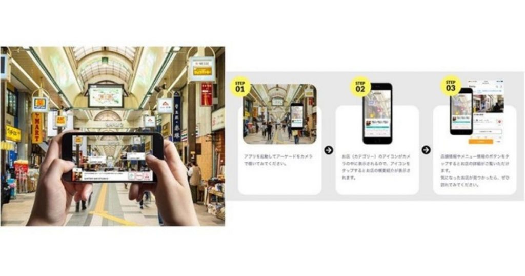
■Outline of this Demonstration
| experimental period | Wednesday, March 10, 2021 - Friday, March 19, 2021 |
| Demonstration site | Sapporo Raccoon Alley Shopping Street (Raccoon Alley 1-7) |
| AR Restaurant Guide URL | https://ar-gourmet-guide.jp |
| Available Devices | iPhone (iOS device) *Only iOS devices can be used for this demonstration. |
| Information obtained from the AR Restaurant Guide App | Information on 90 restaurants in the Raccoon Shoji Shopping Arcade (Raccoon Shoji 1-7) Information on infectious disease countermeasures (New Hokkaido Style) Menu information for 20 stores with mobile ordering system |
| Verification details | 1. Can we promote the digitalization of restaurant selection in the Corona Disaster and provide new experiential value? 2. Will AR guides using 3D city models stimulate new tourism demand in response to the "New Normal"? 3. Identify issues to promote "use by travelers" and "introduction by food and beverage operators |
| Role of each company | JTB Corporation: Overall supervision, development of participating stores, recruitment announcements, and overall verification of the project Provision of mobile ordering system Nice to MEAL you! JTB Research Institute, Inc.: Operation and effectiveness verification of the demonstration survey Toppan Printing Co.: Operation and technical verification of the demonstration survey, server operation Retty Corporation: Provides information on restaurants Super Duper Inc.: Mobile Order System Development |
Future Goals
Toppan Printing, JTB, and JTB Research Institute will work together to resolve issues identified from the results of this demonstration as a private-sector service utilizing a 3D city model, and to promote the service in regions throughout Japan as a new service for the new normal era. In addition to restaurants, the three companies will also promote the expansion of target services to include sightseeing entrance facilities such as shrines, temples, and castles, as well as the promotion of sightseeing tours through the linkage of sightseeing-type MaaS.
In addition, the company will provide multilingual and DX-enabled services in preparation for the recovery of inbound demand, and provide more satisfying and memorable travel experiences for tourists who are unfamiliar with the land or do not speak the language, utilizing digital technology, as well as revitalize local economies and realize safe and secure urban lifestyles.
What is "Project PLATEAU"?
A 3D urban model is a 3D urban spatial information platform that reproduces the urban space itself by adding urban activity information such as name, use, and year of construction to objects such as buildings and streets existing in the urban space. Various urban activity data are integrated into a 3D urban model, achieving a sophisticated fusion of physical and cyber space. This enables advanced urban planning, simulation and analysis of urban activities, etc.
The Ministry of Land, Infrastructure, Transport and Tourism is currently promoting Project "PLATEAU," a "DX for City Planning," which aims to develop 3D city models of about 50 cities nationwide and to realize urban planning, city development, disaster prevention, and creation of urban services, etc., using the models. PLATEAU is promoting the "DX of urban planning" initiative.
[Project "PLATEAU" website:https://www.mlit.go.jp/plateau/
Twitter: @ProjectPlateau
[Ministry of Land, Infrastructure, Transport and Tourism press release]https://www.mlit.go.jp/report/press/toshi03_hh_000068.html
 JA
 EN
